TRACING THE REMAINS OF PALAYAMKOTTAI FORT
Palayam or
Palayappattu refers to an administrative segment during the Vijayanagar Rule
and in the subsequent Nayakkar Dynasty. Palayakkarar or the British colonial
reference of ‘polygar’ indicates the ruler or chieftain of this segment who
were subordinates to the Emperor of Vijayanagar or Madurai. Thus we got a
number of references in the name of Palayam such as Rajapalayam and
Palayamkottai.
There were
several fortified localities / townships in Tirunelveli Cheemai indicated by
their very names such as Palayamkottai, Ukkirankottai, vallvankottai,
Parivallikkottai, Thalaivankottai, Pazhamkottai etc. British references
indicate existence of forts in Vasudevanallur and Nerkattumcheval which were
the main bastions of Raja Puli Thevar who effectively challenged the military might of the British–Arcot Nawab Alliance. Among the above forts, Palayamkottai is a recent one.
There is
hearsay that one Basavappa probably a high ranking official of Vijayanagar
Empire is said to have built this fort. There is one village near
Palayamkottai, in the Tirnelveli–Tuticorin Highways, ‘Vasavappapuram’ said to
be named after him.
However Tinnelvelli
Gazetteer compiled by H.R.Pate, a British ICS officer in 1916, ascribes the
construction of Palayamkottai fort and many other irrigation systems in
Tirunelveli Zilla to Aryanatha Mudaliar, a famous General and the Southern
Viceroy of the legendary Madurai King Viswanatha Nayakka, the first Ruler of
the Nayakka Dynasty. It also mentions that the district was studded with numerous
forts of chieftains.
Colonel James Welsh’s description of
Palayamkottai fort:
Col James
Welsh of the East India Company’s army who was posted as Quarter master of a
brigade encamped near Palayamkottai in the year 1799, describes Palayamkottai
fortification in his book, Military Reminiscence – Volume I [ ‘Military
Reminiscence; An Extract from the journal of nearly forty years’ active service
in the East Indies’]. Palayamkottai was the Tirunelveli district
Headquarters at that time.
Following is the sketch of Palayamkottai fort
presented by the Colonel;
 |
From the
hillock in the backdrop, the temple towers seen along the face of the fort walls, and from the vast
agricultural fields, the sketch appears to be drawn from the North Western side
of the fort.
Col. James Welsh describes,
“the fort is situated upon a
fertile plain, about two miles from the river, with a clear nullah running a
short distance from the walls. It is about two miles in circumference, nearly
square, with two rows of works all round it, but no ditch; the inner rampart
much higher than the outer one, and the whole having small round bastions, and
short curtains, with four gate ways in the middle of the faces, covered by
square redoubts; the two to the West and South being closed up. A capital road
led from the northern gate to the towns
Tinnevelly and Tatchenoor, across the river by a ford, always passable,
excepting during a few days in the North - East monsoon. Some pleasantly
situated garden – houses were close to the road leading to the river, and the
whole of the surrounding country being well watered and wooded, are highly
picturesque and beautiful.”
Another description of the fort:
A 1756,
account of the fort by one Orme as recorded in the Gazetteer says that the fort
was spacious but the ramparts were in ruins, nevertheless capable of resisting
an enemy with no battering cannon.
Portrayal of the fort by Tinnevelly
Gazetteer (1916) compiled by H.R. Pate :
There are
more elaborate details of the fort in this Gazetteer.
The Gazetteer depicts,
“the
fort formed a rectangle 900 yards by 840 yards and possessed neither ditch nor
glacis. It consisted of a main inner rampart, 15 feet high and 15 feet
thick, and an outer line, 9 feet high;
both walls were surmounted by parapets. The ramparts were of earth, faced with
massive cut stones. At irregular intervals there were square bastions, and at
the angles of the fort the bastions were round. At the middle point of each
rampart was a gate. The great square tower, on which, the modern police-station
now reposes surmounted the western or “ Tinnevelly” gate. Just beside the
existing racquet court, which was built up against the southern rampart was the
south or “Travancore” gate. The other entrances – the “ Tiruchendur” gate on
the east the site of which is now
occupied by the sub-magistrate’s court and the northern or “ Madura” gate (
which stood on the site of the present market) – have disappeared.”
The
Gazetteer further elaborates,
“Quarters
for the native soldiers were outside the fort near the Eastern face of the fort
while the British officers stayed inside the fort in the southern part of the
walled township. The artillery barracks was the building, still popularly known
as “Tillery,” in which the post office is now located. The northern two-thirds
of the fort was the crowded town it now is. In the remaining one-third in the
south were the artillery, the mess-house and the bungalows of the military
officers. “
In search
of the traces of the bygone fortification:
The
‘clear nullah’ mentioned by Col.James Welsh is the present day ‘Palayam Kaal’ or Palayam
Canal which fetches water from ‘Pazhavur anaicut’ which is an amazingly very long stone work-diversion barrage built across the river Tamiraparani near
Pazhavur. Palayam canal skirts around the 'fertile and well watered fields' as mentioned by James Welsh. This canal covers the full stretch of Western and
Northern periphery of the present day Palayamkottai town sketching a boundary line on these
two sides. This canal might have been so coursed, so as to serve as a moat to
the fortification; apart from its purpose of irrigation. There are two temple inside the fortified area, Ramar Temple in the Western side and Thiripurantheeswarar Temple in the East with huge tanks. There were narrow canal arrangements
to bring water inside the fort to these tanks.
 |
| The fertile and well watered and scenic surrounding fields as described by Col James Welsh in 1799 are still so. |
Though the
double walled structure of the fort, bastions, redoubts and entrances have almost
withered away, there are few remnants of the ruined fortification which still
stand testimony to the British descriptions.
The ruins of
the redoubts in the Western and Eastern entrances though concealed by modern
developments are still noticeable. The Western entrance of the fort is almost completely intact. This entrance / redoubt is located near the so called ‘Vaikkal
Palam’ [Canal Bridge] area. Atop this redoubt the 'Medai Police Station' referred
by the British records is still functioning in that very name which now houses the City Crime Branch
office. The surrounding massive walls are about 20 feet in height. 'Medai' means
upstairs. This redoubt entrances are
completely closed and the inside entrances house two small temples. Among them 'Sri Prasanna
Vinayagar Temple' is located exactly covering the inner part of the entrance.
‘Mela vassal Murugan koil’ i.e. Western entrance Murugan temple is the
adjoining another temple.
This entire complex is a massive stone structure and was a
part of the old fort system. This complex is connected by the straight South
Bazar road with the Eastern entrance of the fort. The Eastern entrance is though magnificent its remains are hidden behind the huge Samathanapuram Water Tank.
The South Bazar Road is the arterial pathway of the walled township. A bike
ride from the Western entrance to this Eastern structure takes exactly one
kilometer. The remaining part of this redoubt now houses a Govt museum.
Closed
southern entrance of the fort referred by James Welsh might be located near the
present day Central Library and in the road leading to the ‘Ilanthaikulam reservoir’
nearby. This reservoir spread in parallel to the southern face of the former
fort is fed by sub canals from the Palayam canal.
A road from
this southern entrance to Northern Gate of the Palayamkottai fort cuts South
Bazar road at right angles causing a cross road point which is actually the centre of the fort and this path
way passes through the Eastern side of Gopala Swami Temple towards the Western
periphery of the present day vegetable market and merges with the North Bazar
or Tuticorin Road. ‘Kaaval’ i.e. protection deities are part of the features of
ancient forts. The East facing kaval deity, ‘Kottai Karuppa Swamy temple’
located in the middle of a narrow adjoining lane near the Western entrance locality indicates
and corroborates the mainly used Northern entrance of the former fort.
A bike ride
measure from this Northern opening to the centre of the fort measures exactly half a
kilometer. The fort structure being almost square in shape as depicted by Col James Welsh, it can very well be deduced that the entire perimeter of the fort
should have been 4 kilometers. Thus the measurements almost match with the
description of Col James Welsh.
There are no
apparent traces of the ‘double ramparts, the inner being higher than the outer
one’ as described by the Colonel. The basements of which might have gone into
the residential building structures in the narrow lanes and by lanes running
along the northern and Eastern periphery of the Palayamkottai.
The stone
structure with a statue of King Kattabomman atop near Palayamkottai Bus stand
is the other clearly discernible remaining piece of the lost fortification. This might be the
South Western corner-bastion of the former fort. A British period stable was
said to be in the adjoining building which housed a Govt office latter.
The so
called ‘Military lane’ in the North Eastern part of the Palayamkottai is just outside the
fort wall where the native army barracks was located. Quarters for the
native solders were also at the nearby site of the present day District Superintendent
of Police office.
Oomaithurai’s dramatic escape from the
fort prison:
This massive
closet in the Eastern redoubt also served as a prison during the early British
period wherein Kattbomman’s younger brother, Oomaithurai was imprisoned along
with his younger brother Sivathiah @ Duraisingham and 17 other family members
and his close lieutenants for about 13 months after the end of Panjalamkurichy
War I.
Oomaithurai and
his valiant comrades were kept shackled by iron chains in this prison. Panjalamkurichy Kambala
Naikka warriors and several palayakkarar chieftains drew plans to rescue
Oomaithurai out of the gallows. But the plans were postponed and strategies
redrawn for more opportune times. Chinna Marudhu, the Diwan of Sivagangai Cheemai
sent a special task force to rescue his friend, Oomaithurai. But this force unfortunately failed in its attempt. They had been spotted by the British and were arrested
and later executed in public. Details about the identity of the members of this
force and the reasons for their failure are an important piece, lost in the
annals of the glorious history of our Tirunelveli Chemmai. Lack of effective coordination with the Panjalamkurichy men
and need for local intelligence inputs might be the reasons for their failure.
Later, the
Panjalamkurichy men charted out a more meticulous strategy after a month long close surveillance.
Hundreds of Panjalam warriors sneaked into the fort, camouflaging as fire wood
sellers, plantain leaf vendors or as pilgrims concealing weapons and necessary equipments
to break iron chains. Oomaithurai was already informed of the operation. Few fort residents inside the fort also helped these men. Several hundreds of men
spread swiftly across the Eastern face of the fort and all along the escape route to
Panjalamkurichy via Seevalapperi junction point and were in waiting for their next move. On the dusk of that chosen day, the British officers in the garrison were away at the palace of
Ettayapuram Raja on the other side of the Tamiraparani river bank enjoying a party hosted by the Raja.
This palace called 'Castle Wood' and its sprawling surroundings are still intact in
Tirunelveli Junction behind the so called vast Raja Building complex. The
Panjalamkurichy men made a synchronized and lightning attack on the garrison
and disarmed the British sentry and rescued all the inmates of the prison paving the way for Panjalamkurichy War - II and the ensuing famous Polygar Wars or South Indian Rebellion.
Surroundings of the fort:
On the side
track, Col James Welsh in his book further says, ‘The town of Tinnevelly or
Tirnawelly as the natives call it, is very large, and contains very wealthy
Hindoo merchants; and Tachenoor, which is much smaller, had a cavalry
cantonment formed near it.’ He also mentions about a ‘ford’ which might be the
traditional path used by the people to cross the river Tamiraparani before the
construction of bridges across the river. This shallow path way might be
between the stone paved and stepped banks / 'Padithurai' at Vannarpettai on one
side and Sindhupoondurai Padithurai on the other side of the bank.
Destruction of the fort:
How come the
Nellai Cheemai’s forts withered away and disappeared from the public memory?
In 1795, the
British East India Company regime in Fort St. George of Madras issued a decree
directing the Polygars to destroy their forts and surrender their weaponry.
This decree was effectively implemented after the so called Polygar Wars in the regions formerly ruled by the native Chieftains and Rulers who opposed the British colonization.
For example,
the H.R.Pate’s ‘Tinnevelly Gazateer’ says, ‘the Panjalankurichi fort was razed
to the ground; the site was ploughed over and sown with castor seed, and the
name of the place was also expunged from all the registers of the district.’
Another telling
example is that the present day Marret Streets around the core of Madurai city are
actually the stretches where the moats ran around the Madurai Fortification. These
streets were created by filling the moats by pulling down the fort walls. The
streets are named after the British officer and the natives who helped him in accomplishing this work! The
‘Veli’ Veedhi meaning outer Streets were the ones running outside the famed fort
of Madurai. One massive side bastion of a redoubt located just adjacent to the Bus
Terminus near Nethaji Road is the only remaining piece of the Madurai fort at
present. This area is still known as 'Western entrance' by the locals. The 'southern entrance' to the Madurai fort is also still called in the same name.
All the ancient Pandya forts were brick or mud works and presumably smaller in size. After the advent of Vijayanagar rule in Madurai region, particularly King Viswanatha Nayak converted the Madurai and Tirunelveli [Palayamkottai?] forts into double walled stone masonry works.
All the ancient Pandya forts were brick or mud works and presumably smaller in size. After the advent of Vijayanagar rule in Madurai region, particularly King Viswanatha Nayak converted the Madurai and Tirunelveli [Palayamkottai?] forts into double walled stone masonry works.
By razing
down the forts and confiscating the weapon stocks in the restive regions, the
British colonizers tried to preempt further rebellions. These were the attempts
to emasculate us by obliterating the memories of our valorous ancestral history
and heritage.
The southern Tamil Country, Nellai Cheemai has always been a fertile nursery of valorous and patriotic lions who stood against the alien might in the service of this country. This actually explains the disappearance of many forts in Nellai Cheemai.
However in
the case of dilapidation of Palayamkottai fort, which only served as a British cantonment
and prison for a long time from the initial stages of colonization i.e. from 1765
there were other reasons too.
The
Gazetteer narrates thus,
“The disappearance of the old fort was
a gradual process. As early as 1840 a large quantity of stone had been taken
from the outer wall for the purpose of building the foundations of the bridge
at Tinnevelly. The eastern gate had been shut up and on its site a civil jail
(now the court of the sub magistrate) had been built; the other gates were in
existence, but there were innumerable breaches, especially on the west side,
and pieces of wall were constantly collapsing. Mr. E.B.Thomas, the Collector,
recommended in the interests of the public health that the outer wall at least
should be completely removed, and, though the military authorities opposed the
suggestion, its destruction was ordered in 1844 by Government. A few years
later – in 1851- the demolition of the main wall on the east was put in hand,
and permission was obtained to use the stones for public buildings. In 1860 the
removal of the western wall followed; the southern wall was destroyed next and
last of all, the northern wall. By 1861 the fort had practically disappeared.
The stones were sorted, good ones being retained for various public works and
the best of all sent off to Srivaikuntam for the new anicut. The rest were
sold.”
The few remains
of the Palayamkottai fort particularly the Western Gate structure is in need of
repairs. It is high time to conserve and popularize these heritage pieces of historic
and antique value of this land.
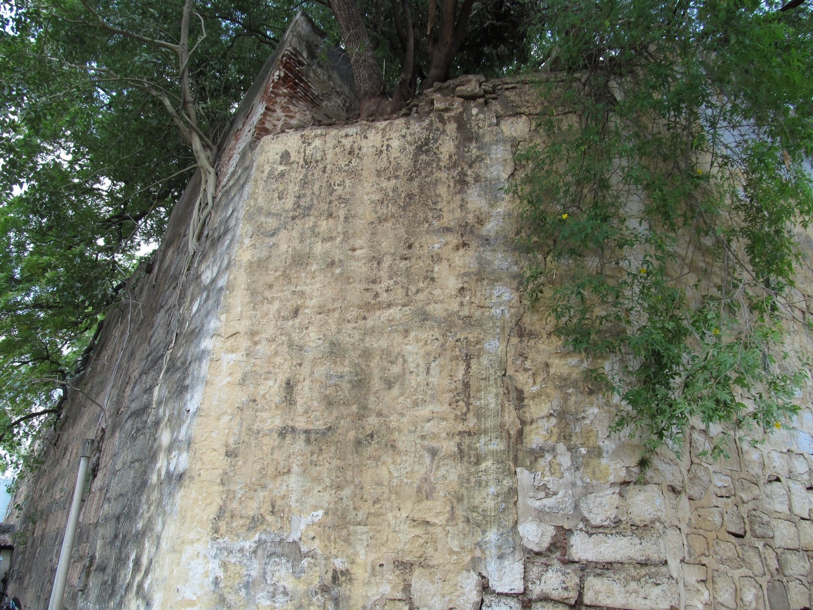
The parapet walls of the Western redoubt structure:


The stone tiled outer walls of the Western redoubt structure:


Closed Western Gate:

Temple precincts in the inner side of the Western redoubt: :

--:: O :: --
just awesome
ReplyDeleteNice work
ReplyDeleteOne of the best papers I've read. Thank you for this
ReplyDeleteAs a child I have visited the Katta Bomman statue memorial as well as the Kotta Police station. Always asked my father (a history professor) about the rest of the fort and told him there a lot a huge stones with lion and other engravings in some of our school building. He used to say "hmm you are walking on history". Thank you for posting the article.
ReplyDelete👏👏👏
ReplyDelete